Albedo is a key parameter that controls the energy exchange between the atmosphere and snow or ice surfaces, playing a crucial role in estimating glacier melt and mass balance. While commonly measured in the field with pyranometers, these instruments have limited spatial coverage due to their footprint. Therefore, remote sensing offers the best option for deriving snow and ice albedo data and analysing its spatial and temporal variability. SatRbedo is an extensible, well-documented package for retrieving snow and ice albedo from optical satellite images, such as Landsat and Sentinel-2. It requires the following input datasets:
- Atmospherically corrected surface reflectance (gridded).
- Satellite (\(\varphi_v\), \(\theta_v\)) and solar (\(\varphi_s\), \(\theta_s\)) azimuth and zenith angles (numeric or gridded).
- A digital elevation model (DEM) (gridded).
- An outline of the area of interest (shapefile).
The SatRbedo package has been designed for researchers, consultants, and individuals interested in exploring changes in snow and ice albedo. It includes the following functions:
-
preproc()provides tools for image pre-processing, including cropping grids to a specified extent, projecting grids with different coordinate systems, and converting data from integer to floating point. -
cfactor_BRDF()converts nadir satellite observations to off-nadir values using view-angle corrections. -
cast_shadows(),hill_shade(), andshadow_removal()detect and mask topographic shadows. -
topo_corr()andtopo_splot()provide tools to correct surface reflectance for the effects of topography and to visualise the dependency of surface reflectance on the illumination condition. -
snow_or_ice(), andNDSII_hist()are used for the automatic discrimination of snow and ice surfaces. -
f_BRDF()performs the anisotropic correction of reflected radiation of glacier snow and ice using empirical parameterisations of the bidirectional reflectance distribution function (BRDF). -
albedo_sat()calculates narrowband and broadband albedo from surface reflectance data. The albedo retrieval methods include corrections for the anisotropic behaviour of the reflected radiation field over snow and ice, as well as narrow-to-broadband albedo conversion algorithms. -
albedo_Knap(),albedo_Feng(), andalbedo_Liang()convert narrowband to broadband albedo.
Installation
You can install SatRbedo with:
install.packages('SatRbedo', repos = c('https://pabl1t0x.r-universe.dev', 'https://cloud.r-project.org'))Getting Started
Snow and ice albedo retrieval from satellite imagery is a four-step workflow that includes image pre-processing, topographic and anisotropic corrections, and a narrow-to-broadband albedo conversion (Fig. 1).
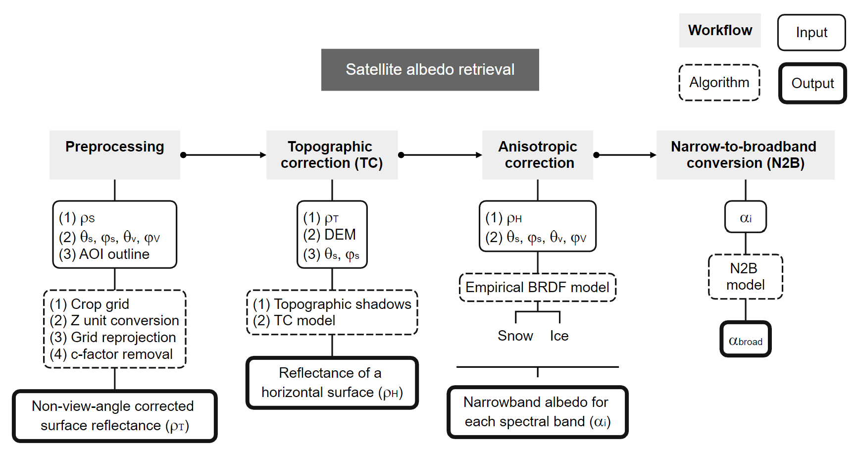
Fig. 1 Flowchart of the satellite albedo retrieval workflow
A basic usage example of estimating satellite albedo from Sentinel-2 surface reflectance data can be found here.
Contributing
All contributions are welcomed. See our Contributing Guidelines for more details.
Citing
Please cite SatRbedo using:
@article{
  title = {{SatRbedo}: {An} {R} package for retrieving snow and ice albedo from optical satellite imagery},
  author = {Fuchs, Pablo and Dadic, Ruzica and MacDonell, Shelley and Purdie, Heather and Anderson, Brian and Katurji, Marwan},
  journal = {Journal of Open Source Software},
  year = {2026},
  volume = {11},
  number = {117},
  pages = {8973},
  doi = {10.21105/joss.08973}
}
License
This project is licensed under the terms of the GNU General Public License v3.0. See LICENSE for more details.